
ArticleEngineering & construction
When a School Slowly Slides Towards a River - A Forensic Engineering Reflection on Deep-Seated Landslides in Tasmania
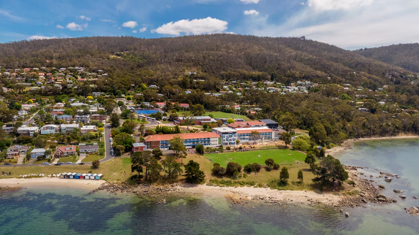
Introduction
As a registered Civil/Structural Engineer and Builder in Tasmania, I have been involved in a range of slope and embankment stabilisation projects across the state, together with associated building remediation and structural strengthening works arising from ground movement.
For those working in Tasmania’s remedial, structural and geotechnical sectors, the situation at Taroona is hardly unknown. It has long been understood within the industry that the Taroona school precinct sits within a mapped deep-seated landslide hazard zone.
Recent media coverage has simply brought this long-standing geotechnical issue back into public attention.
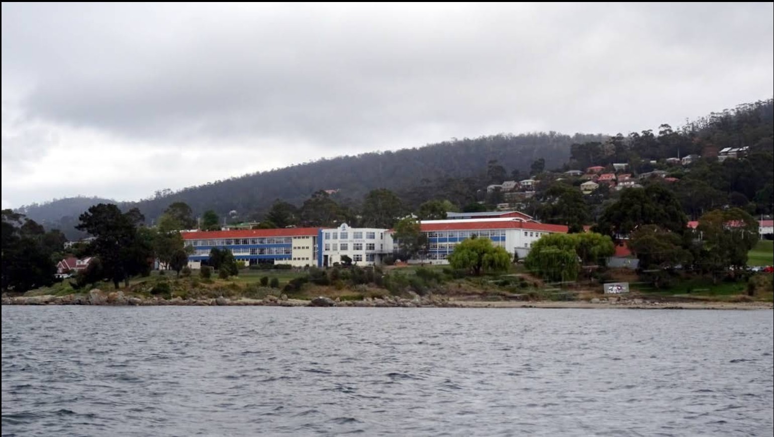
At first glance, Taroona High School appears to sit peacefully along the shoreline of the River Derwent in Hobart, surrounded by water, bushland and residential hillsides. But beneath the surface, the ground itself may have been slowly moving for decades.
Movement rates of only a few millimetres per year may sound insignificant to the public. From an engineering perspective, however, such movement is more than enough to progressively damage:
- buildings,
- pavements,
- retaining structures,
- underground services,
- drainage systems,
- and other critical infrastructure over time.
This is not simply a local retaining wall issue.
It is a much larger deep-seated slope movement and long-term asset risk management problem.
Figure 1. Viewed from the River Derwent, the scale of Taroona High School and its surrounding hillslope system becomes immediately apparent.
The Bigger Picture: The Official Landslide Hazard Map
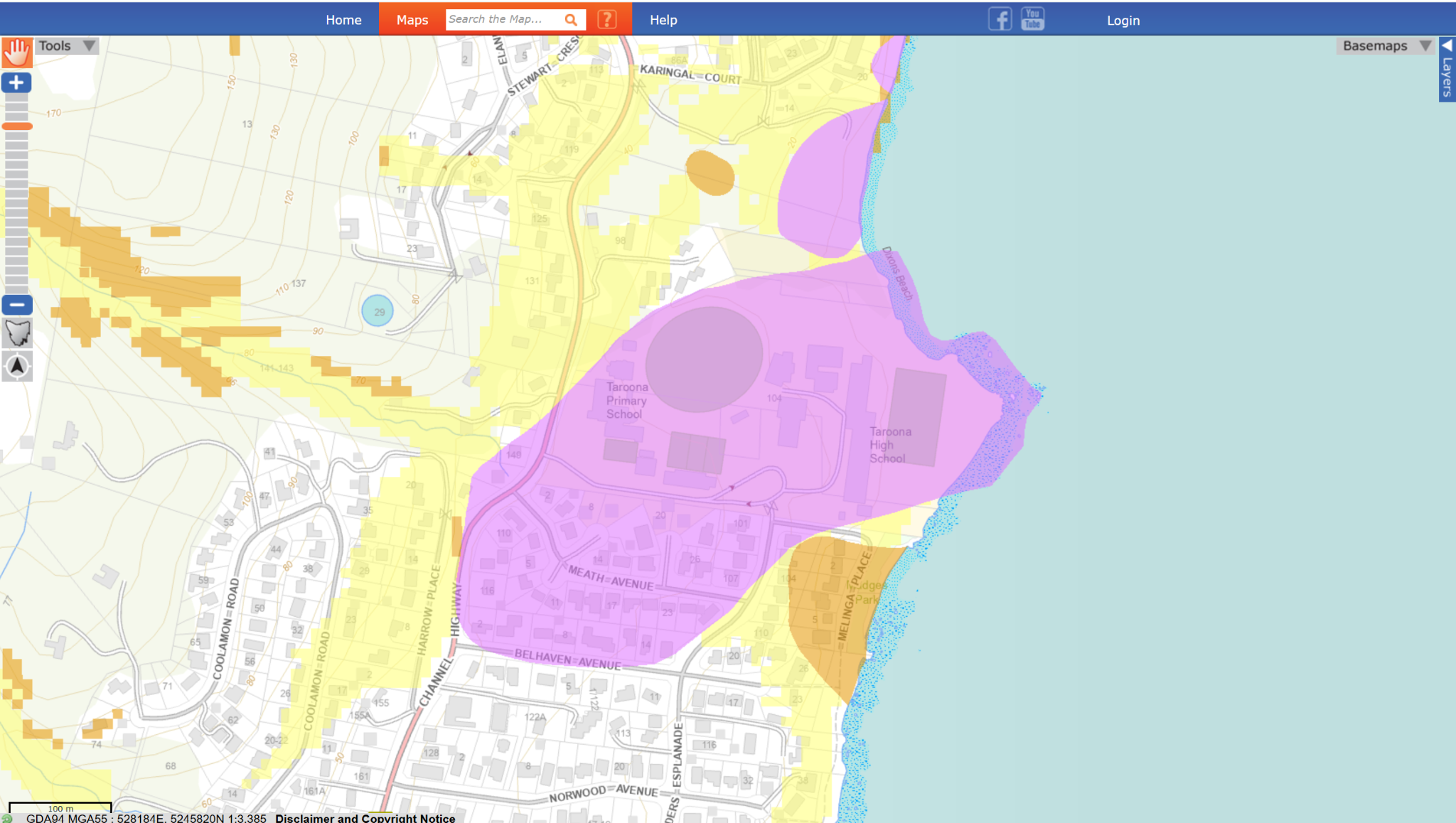
One of the most revealing pieces of publicly available information is the Landslide Hazard Map published by Mineral Resources Tasmania (MRT).
The mapped hazard zone does not merely affect one isolated retaining wall or building. Instead, it extends across a large section of the hillside from the upper residential areas down towards the River Derwent foreshore.
Importantly, the mapped landslide body appears to include:
- Taroona Primary School,
- Taroona High School,
- nearby residential areas,
- and the shoreline itself.
This strongly suggests that the issue may involve:
a deep-seated hillslope movement system
rather than a shallow localised landslip.
The geometry of the mapped hazard area is particularly telling. The elongated and bulb-shaped morphology resembles the classic form of a large slow-moving landslide body extending downslope toward a toe zone near the shoreline.
Figure 2. The official MRT landslide hazard map indicates a broad hillslope instability zone extending from the upper hillside to the Derwent foreshore.
Not All Landslides Are the Same
One of the most common misconceptions about slope failures is the assumption that all landslides behave similarly.
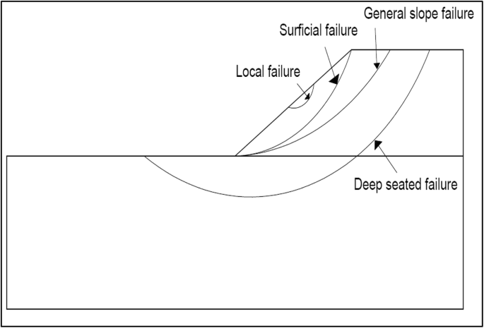
In reality, a single slope can contain multiple potential failure mechanisms simultaneously.
These may include:
- surficial failures,
- local rotational slips,
- general slope failures,
- and deep-seated landslides.
In many cases, shallow failures visible at the surface are merely symptoms of a much larger and deeper governing mechanism beneath.
From a forensic engineering perspective, the key question is not:
“Where is the crack?”
but rather:
“What is the governing failure mechanism?”
This distinction is critical because remediation strategies that are effective for shallow failures may be ineffective for large deep-seated slope movements.
Figure 3. Different landslide mechanisms can exist simultaneously within the same slope system. The deepest governing slip surface typically controls overall stability.
A Possible Mechanism at Taroona
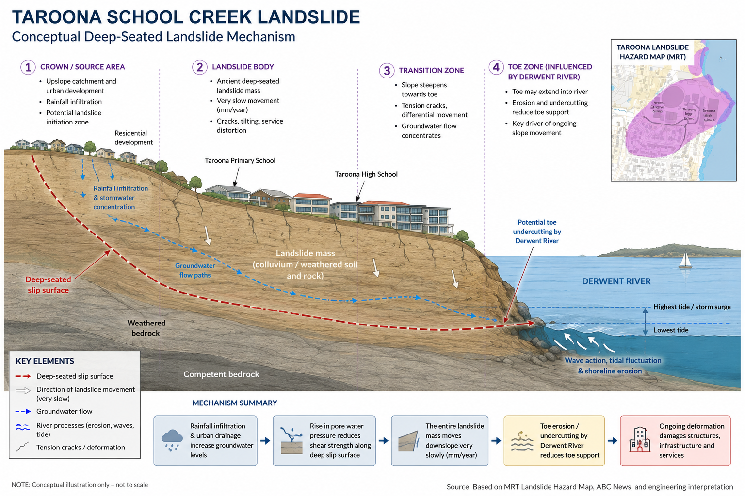
Based on publicly available terrain data, aerial imagery, hazard mapping and the geomorphology of the area, one possible interpretation is that the Taroona site may involve:
a reactivated ancient deep-seated landslide system.
Several interacting factors may be contributing simultaneously:
- long-term rainfall infiltration,
- concentrated groundwater flow,
- urban drainage modification,
- additional loading from hillside development,
- and progressive toe weakening near the shoreline.
The terrain itself provides several important clues:
- a long continuous hillside catchment,
- residential development upslope,
- the schools located near the lower slope,
- and direct exposure to the River Derwent at the toe zone.
Together, these characteristics are highly consistent with deep-seated hillslope creep behaviour.
Figure 4. Conceptual interpretation of a possible deep-seated landslide mechanism affecting the Taroona hillside and Derwent foreshore.
The River May Be Part of the Problem
One particularly important consideration is the relationship between the slope toe and the River Derwent itself.
It is possible that the toe of the landslide extends into the foreshore or shallow subsurface near the river edge.
If so, long-term shoreline processes may gradually reduce toe support through:
- wave action,
- tidal fluctuation,
- shoreline erosion,
- seepage,
- and progressive undercutting.
This does not necessarily imply rapid catastrophic collapse.
In fact, deep-seated landslides often behave in the opposite way:
extremely slow — but continuous — movement over decades.
Even movements measured in millimetres per year can progressively damage infrastructure and accumulate into major long-term asset management problems.
Why Retaining Walls Alone May Not Solve the Problem
When the public hears the word “landslide”, the immediate reaction is often:
“Why not just build a retaining wall?”
However, retaining structures are only effective when they interact with the governing slip surface.
If the primary failure mechanism is very deep and the landslide body is extremely large, then:
- shallow retaining walls,
- soil nails,
- short anchors,
- or localised stabilisation works
may only control superficial deformation rather than the movement of the entire slope system.
This is one of the defining challenges of deep-seated landslides.
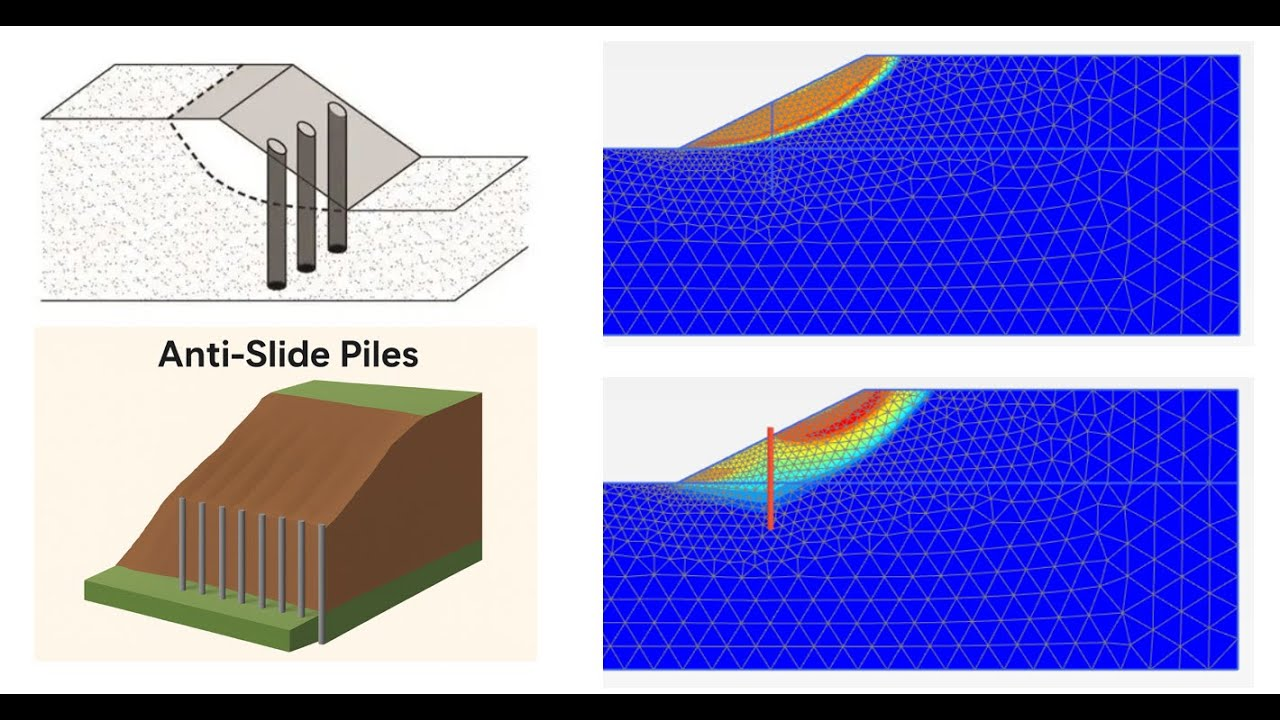
Figure 5. Anti-slide piles can be highly effective for certain slope failures, but their performance depends heavily on slip surface depth, landslide geometry and the scale of slope movement.
Why Even Anti-Slide Piles May Not Fully Stabilise Large Deep-Seated Landslides
Anti-slide piles are among the most powerful stabilisation tools available in geotechnical engineering.
Under the right conditions, they can significantly improve slope stability by transferring lateral forces into competent founding material below the slip surface.
However, their effectiveness depends on several critical factors:
- depth of the governing slip surface,
- size of the landslide mass,
- groundwater conditions,
- strength of the stable founding layer,
- and whether the piles can fully intercept the critical failure mechanism.
For relatively shallow or localised failures, anti-slide piles may perform extremely well.
Deep-seated landslides, however, present a far greater challenge.
If the governing slip surface extends deeply beneath the hillside, piles may become:
- excessively long,
- structurally demanding,
- difficult to construct,
- and economically impractical.
In some cases, piles may reduce local deformation while the broader landslide mass continues to creep slowly downslope over time.
At that stage, engineering strategy often shifts away from attempting to completely “stop” movement, and instead focuses on:
- groundwater control,
- drainage improvement,
- monitoring,
- targeted stabilisation,
- shoreline protection,
- and long-term risk management.
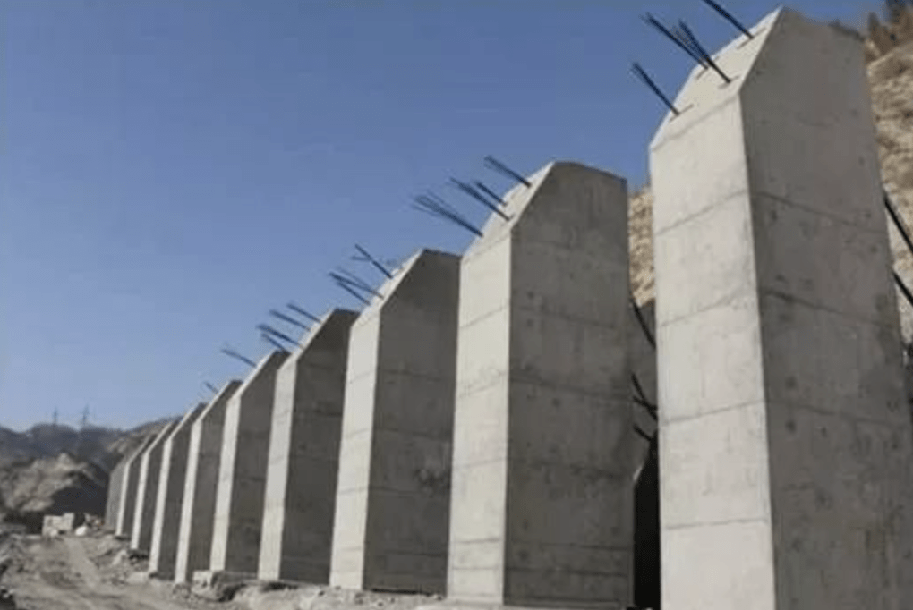
Figure 6. Large anti-slide pile systems often require substantial structural capacity and deep embedment below the governing slip surface.
Ancient Landslides Never Truly Disappear
One of the most important lessons in engineering geology is this:
"Ancient landslides rarely truly “disappear”.
Many remain dormant or marginally stable for centuries before changes in:
- groundwater,
- rainfall,
- erosion,
- climate patterns,
- drainage,
- or urban development
gradually reactivate movement.
Tasmania’s steep coastal terrain, weathered geology and evolving urban environments make this a particularly important issue for long-term infrastructure planning.
Engineering Reality: Sometimes We Manage Movement Rather Than Eliminate It
For complex landslide systems such as this, engineering solutions often involve a combination of:
- groundwater management,
- subsoil drainage,
- slope monitoring,
- instrumentation,
- targeted stabilisation,
- shoreline protection,
- and long-term asset planning.
This is an important distinction.
For large deep-seated landslides, engineering success may not necessarily mean:
Making the slope completely immobile.
Instead, it may mean:
Reducing movement to an acceptable and manageable level over time.
Final Reflection
One of the humbling realities of forensic and geotechnical engineering is that the ground beneath us is never truly static.
Buildings, roads and schools may appear permanent to the public — but the landscapes supporting them are often still evolving slowly beneath the surface.
Sometimes, the greatest engineering challenge is not resisting a sudden disaster.
It is understanding and managing a geological process that moves almost invisibly, year after year, decade after decade.
And in places like Taroona, the landscape itself may still be quietly reshaping the future of the community built upon it.
#GeotechnicalEngineering #ForensicEngineering #Landslide #SlopeStability #EngineeringGeology #GroundMovement #SlopeFailure #DeepSeatedLandslide #EmbankmentStabilisation #RemedialEngineering #CivilEngineering #StructuralEngineering #Tasmania #Hobart #Taroona #RiskManagement #Infrastructure #AssetManagement #Groundwater #ShorelineErosion