
ArticleLandslide risk
McCrae Landslide and Victoria’s New Planning Controls: 18 Months On

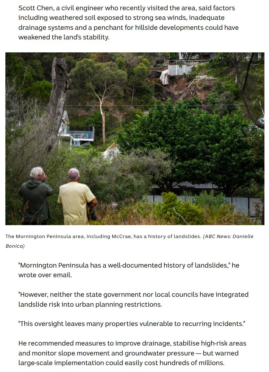
I recently came across the latest planning changes being pursued by the Victorian Government and Mornington Peninsula Shire in response to landslide risk across the Peninsula. What surprised me was how closely some of these measures align with the issues I raised when ABC News interviewed me following the McCrae landslide in January 2025.
At the time, I commented that the Mornington Peninsula had a well-documented history of landslides, yet landslide risk had not been adequately incorporated into planning controls. I suggested better drainage, targeted stabilisation of high-risk slopes, and monitoring of slope movement and groundwater conditions. I also raised the question of cost: if major stabilisation works were undertaken across landslide-prone areas of the Peninsula, the total cost could run into hundreds of millions of dollars.
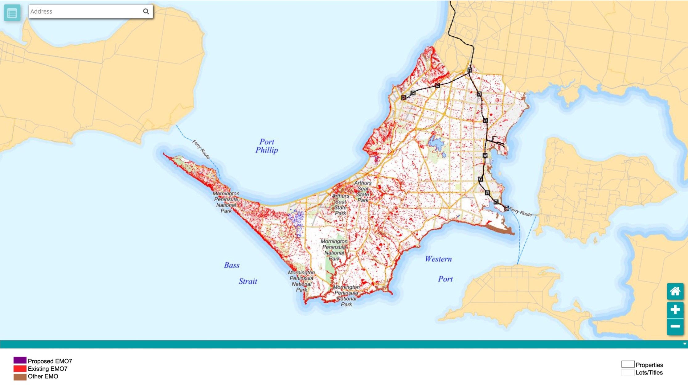
Since then, the McCrae Landslide Board of Inquiry has examined the incident and the broader management of landslide risk in Victoria. This was followed by the introduction of Erosion Management Overlay Schedule 7 (EMO7) in January 2026. Despite its name, EMO7 is principally aimed at managing landslide risk in areas identified as highly susceptible.
The initial overlay affected approximately 33,000 properties across the Mornington Peninsula. Mornington Peninsula Shire is now proposing a major refinement through Amendment C314morn. Based on updated mapping, geotechnical review and ground-truthing, the number of affected properties would fall to around 6,000.
That is a substantial change and highlights the importance of getting the underlying hazard mapping right. Planning controls of this scale can have significant consequences for property owners and future development, so they need to be supported by reliable data and sound geotechnical assessment. The latest refinement should provide a better basis for identifying the areas where landslide risk genuinely warrants closer planning and engineering scrutiny.
Cost is equally important. Identifying landslide-prone land does not mean that every slope should be physically stabilised. In established hillside communities, remediation can involve retaining structures, piles, ground anchors, drainage works and monitoring, often around existing houses, roads and underground services. The cost can escalate very quickly.
A practical response therefore needs to be proportionate to the actual risk. Some locations may require substantial stabilisation works, while others may be managed through drainage improvements, monitoring, restrictions on excavation or development, or relatively modest local works. In many cases, controlling inappropriate development before problems arise will be considerably cheaper than retrofitting major stabilisation works afterwards.
A Comparison with Tasmania
Those who know me professionally will know that I am also a registered engineer and licensed builder in Tasmania and have worked there extensively over the years. Seeing these changes in Victoria naturally reminded me of Tasmania’s approach to landslides and other natural hazards.
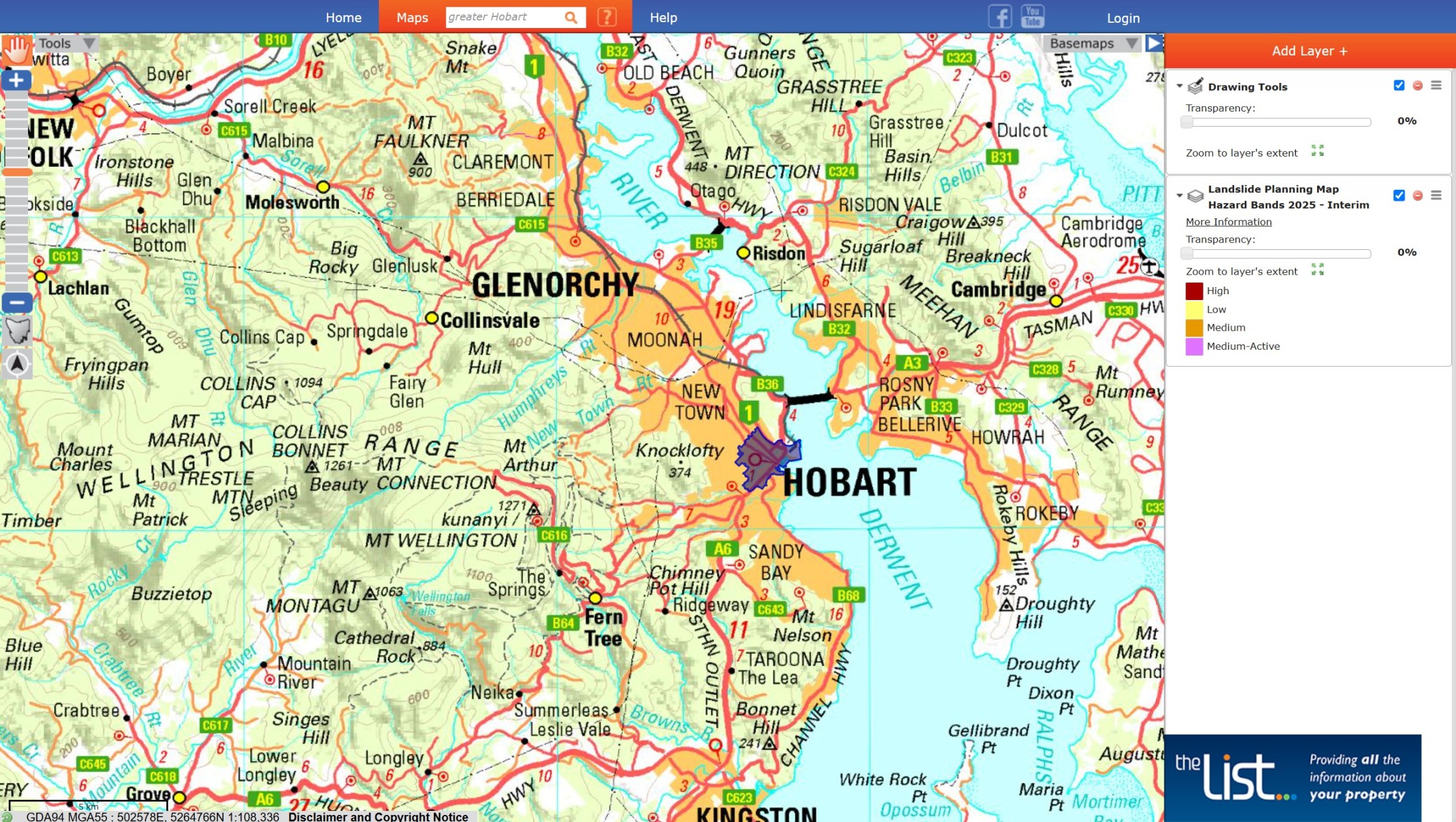
Tasmania has long incorporated landslide hazard mapping into its statutory planning framework through the Landslip Hazard Code, supported by hazard-band mapping and geological work undertaken by Mineral Resources Tasmania. Flood-prone areas are similarly addressed through statutory planning controls, while Hobart has developed detailed flood mapping and stormwater risk-management measures.
The Tasmanian framework uses hazard mapping to determine where additional planning controls or specialist assessments are required. It does not assume that every identified slope requires physical remediation. Depending on the hazard and proposed development, the response can range from planning restrictions and further geotechnical assessment to drainage works, monitoring or structural stabilisation.
Having worked on hillside and slope-stability projects in Tasmania, I have always regarded this as a sensible approach. Natural hazards cannot realistically be eliminated across an entire developed region, particularly when the engineering cost of doing so would be enormous. The important issue is having sufficiently reliable information to determine where intervention is actually warranted.
Back to the Mornington Peninsula
Water remains one of the most important factors in slope stability. Groundwater, leaking infrastructure, uncontrolled stormwater and changes to natural drainage can increase pore-water pressures and materially change slope behaviour. On susceptible terrain, drainage and underground services therefore cannot always be treated separately from the geotechnical assessment of the slope.
This is also why the refinement of EMO7 matters. Reducing the affected properties from approximately 33,000 to around 6,000 does not make the underlying landslide issue any less important; it should, however, allow planning and engineering attention to be directed more accurately towards the areas where the hazard is genuinely significant.
Looking back, it is interesting to see that many of the issues I raised with ABC News in January 2025 are now reflected in the planning response following the McCrae landslide.
The latest refinement of EMO7 is sensible. Landslide risk on the Mornington Peninsula is real, but the controls need to be based on accurate mapping and sound geotechnical evidence, particularly when thousands of properties and potentially substantial remediation costs are involved.
For me personally, it has been interesting to follow what has happened since that ABC interview 18 months ago. McCrae was a reminder that some engineering risks develop quietly for years before they suddenly become very visible. If one positive thing can come from what happened there, I hope it is a more informed and practical approach to managing landslide risk — before the next major failure occurs.
#LandslideRisk #GeotechnicalEngineering #CivilEngineering #MorningtonPeninsula #RiskManagement #UrbanPlanning #Victoria
Author: Scott CHEN